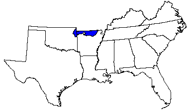

Land use: About 70 percent of this area is forests or woodland, most of which is in large holdings, national forests, or farm woodlots. About 20 percent is pasture, mainly of introduced grasses and legumes. About 10 percent is cropland. Corn, feed grains, and hay for dairy cattle and other livestock are the principal crops. Orchards, vineyards, and truck crops are important on some of the more friable deep soils. Summer droughts and steep slopes are major land use problems.
Elevation and topography: Elevation ranges from 200 to 500 m. These sharply dissected limestone plateaus have narrow rolling ridgetops that break sharply to steep side slopes. Valleys are narrow and have steep gradients, especially in the upper reaches. Local relief is in meters to tens of meters.
Climate: Average annual precipitation - 1,025 to 1,225 mm. Maximum precipitation is in spring and early in summer, and the minimum is in midsummer. Average annual temperature - 13 to 16 C. Average freeze-free period - 180 to 200 days.
Water: The moderate precipitation is adequate for crops and pasture. On most farms shallow wells or springs supply water for domestic needs and for livestock, but deep wells are required for large quantities. Water from deep wells is of good quality but is hard. Small ponds on many individual farms provide some water for livestock, and a few large reservoirs are used for flood control and for recreation.
Soils: Most of the soils are Udults and Udalfs. They are deep, medium textured to fine textured, cherty soils that weathered from limestone. They have a mesic temperature regime, an udic moisture regime, and siliceous or mixed mineralogy. Somewhat excessively drained to well drained Paleudults (Clarksville, Coulstone, Macedonia, Noark, and Poynor series) and Paleudalfs (Peridge and Goss series) are on ridges and side slopes. Moderately well drained, nearly level to moderately steep Fragiudults (Captina and Nixa series) are on slopes. Somewhat excessively drained, shallow Hapludolls (Gasconade series) and areas of rock outcrop are on steep, dissected landscapes. Udifluvents (Midco and Elsah series) on flood plains and Hapludalfs (Razort and Secesh series) on terraces are in stream valleys. Fine textured Hapludults (Agnos and Gassville series), Paleudalfs (Gepp series), and Paleudults (Doniphan series) also occur.
Potential natural vegetation: This area supports oak-hickory and oak-hickory-pine forests. Oak-hickory-pine forests are more dominant in the east. Glades, openings having bedrock outcrops or that are shallow to bedrock, support a more herbaceous vegetation consisting primarily of indiangrass, little bluestem, and dropseeds. Glades are more common in the southwest.
(From "Land Resource Regions and Major Land Resource Areas of the United States". United States Department of Agriculture Soil Conservation Service Handbook 296. Dec. 1981. page 84.)