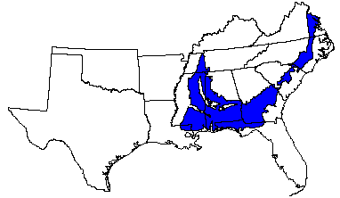

Land use: This area is about 69 percent woodland, 17 percent cropland, and 11 percent pastureland. About 3 percent of the area is used for rangeland, urban development, or other purposes. The woodland is 65 to 75 percent privately owned and 25 to 35 percent industry owned. A small percentage is federally owned. Timber production is important. Cash crops include soybeans, corn, peanuts, and cotton. Major vegetable crops, melons, tobacco, and pecans are important in some parts. Recently, livestock farming has increased. Pastures are used mostly for beef cattle, but some dairy cattle and hogs are raised. Controlling soil erosion and improving drainage on low wetland areas are major concerns of management.
Elevation and topography: Elevation ranges from 25 to 200 m, increasing gradually from the lower Coastal Plain northward. The area is strongly dissected into nearly level and gently undulating valleys and gently sloping to steep uplands that are underlain by unconsolidated sand, silt, and clay. Stream valleys generally are narrow in their upper reaches but become broad and have widely meandering stream channels as they approach the coast. Local relief is mainly a few meters, but in some of the more deeply dissected areas relief is 25 to 50 m.
Climate: Average annual precipitation-1,025 mm in the north to 1,525 mm in the south. Minimum precipitation is in autumn throughout the area. In the east maximum precipitation is in midsummer, and in the west it is in winter and in spring. Average annual temperature-16 to 20 C, increasing from north to south. Average freeze-free period-200 to 280 days, increasing from north to south.
Water: Precipitation, perennial streams, and ground water provide an abundance of water. Domestic water supplies are obtained mainly from shallow wells and water for livestock from perennial streams and small farm ponds. In most places, one or more aquifers provide ample ground water for municipal and industrial uses. The many perennial streams have the potential for supplying water for municipal use, human consumption, and farming but have been little used for these purposes. A few large reservoirs are available for recreation and other uses.
Soils: The dominant soils are Udults. They are deep and have a thermic temperature regime, an udic moisture regime, a loamy or sandy surface layer, and a loamy or clayey subsoil. Well drained and moderately well drained, nearly level to strongly sloping Paleudults (Bama, Bowie, Dothan, Malbis, Norfolk, Orangeburg, Red Bay and Ruston series) are on uplands. Well drained gently sloping to steep Hapludults (Cahaba, Cuthbert, Kirvin, Luverne, Saffell, and Sweatman in the south and Suffolk, Emporia, Rumford, Kenansville, and Craven in the north) are on uplands. Associated with these soils in less sloping areas are the moderately well drained and somewhat poorly drained, loamy Fragiudults (Ora, Bourne, Pheba, and Savannah series), Fragiudalfs (Dulac and Providence series), Paleudults (Clarendon and Goldsboro series) and the well drained to moderately well drained, clayey Paleudults (Angie, Faceville, Greenville, Marlboro, and Shubuta series). Other well drained, nearly level to steep Paleudults (Darco, Fuquay, Lucy, Troup, and Wagram series), which have a thick sandy surface layer, are on uplands. Less extensive but locally important soils are the nearly level to moderately steep Quartzipsamments (Alaga, Kershaw, and Lakeland series) on uplands (mostly in the south), Paleudalfs (Atwood, Boswell, Millwood, and Susquehanna series) and Glossaqualfs (Aldine, Caddo, Guyton, Mollville, Waller, and Wrightsville series) (in the southwest), Paleudalfs (Lexington series) on some loess-capped hilltops in the north-central part of the area, and nearly level Ochraquults (Amy, Myatt, Rembert, and Weston series), Albaquults (Cantey and Leaf series), and Paleaquults (Byars, Coxville, Pantego, and Plummer series) on low wetland. Bottom land soils include Udifluvents (Colling, Iuka, and Ochlockonee series), Fluvaquents (Bibb, Falaya, Mantachie, and Waverly series), and Dystrochrepts (Chenneby and Ouchita series).
Potential natural vegetation: This area supports mixed oak-pine forest vegetation. Loblolly, longleaf, slash, and shortleaf pines; sweetgum; yellow-poplar; and red and white oaks are major overstory species. Dogwood, gallberry, and farkleberry are major understory species. Common sweetleaf, American holly, greenbrier, southern bayberry, little bluestem, Elliott bluestem, threeawn, grassleaf goldaster, native lespedezas, and low panicums are other understory species.
(From "Land Resource Regions and Major Land Resource Areas of the United
States". United States Department of Agriculture Soil Conservation Service
Handbook 296. Dec. 1981. page 95 - 96.)