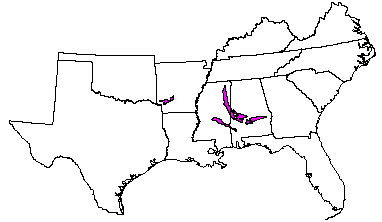

Land use: In Alabama and Mississippi, this area is about 58 percent woodland, 26 percent pastureland, and 14 percent cropland. The small outlier in Arkansas is about 40 percent pastureland, 33 percent woodland, and 25 percent cropland. Most soil areas have been disturbed, and only small remnants of the former prairie vegetation remain. About 2 percent of the area is used for urban development or for other purposes. Soybeans are the major crop, but corn, small grains, and cotton are also grown. Pastures are used mainly for beef production, but in some places dairying is an important industry. The woodland is about 75 to 80 percent privately owned, and about 20 to 25 percent is owned by industry. This is not a very productive woodland area. Controlling soil erosion and infestation of Johnsongrass on soils that are cultivated are major concerns of management.
Elevation and topography: Elevation ranges from 25 to 100 m. Some of the more prominent valley floors are less than 25 m, and a few ridgetops exceed 100 m. Valley floors, side slopes, and ridgetops are underlain by clay, marl, and chalk. Local relief is mainly a few meters.
Climate: Average annual precipitation-1,225 to 1,425 mm. Maximum precipitation is early in winter, in spring, and in midsummer; the minimum is in autumn. Average annual temperature-16 to 18 C, decreasing from south to north. Average freeze-free period-220 to 260 days.
Water: Precipitation and perennial streams are important sources of water, but ground water from moderately deep and deep wells is the principal source for both domestic and municipal uses. Ponds provide water for livestock, and locally they are used for recreation. A few large reservoirs are available for recreation and other uses.
Soils: The dominant soils are Ochrepts and Udalfs. They are fine textured and have a thermic temperature regime, an udic moisture regime, and montmorillonitic or carbonatic mineralogy. They are mainly moderately deep to deep over soft limestone or chalk and typically shrink, swell, and crack. Well drained Eutrochrepts (Sumter series) and moderately well drained to poorly drained Hapludalfs (Oktibbeha and Vaiden series), all of which are nearly level to gently sloping and strongly sloping, are on wide ridgetops and narrow side slopes. Shallow Udorthents (Demopolis series) occur locally but are of small extent. Moderately well drained to poorly drained, nearly level to gently sloping Haplaquepts (Leeper series) and Chromuderts (Terouge series), Hapludolls (Catalpa series), and Pelluderts (Eutaw and Trinity series) are on bottom land and in low upland areas. The outer perimeter of the area is intermittently ringed with moderately well drained to somewhat poorly drained Paleudalfs (Boswell and Susquehanna series) and moderately well drained and well drained Hapludults (Saucul and Saffell series).
Potential natural vegetation: This area supports deciduous hardwood forest vegetation. Red oak, white oak, sweetgum, and blackgum are the dominant overstory species. Eastern redcedar, dogwood, and osage orange are major midstory species. Japanese honeysuckle, greenbrier, little bluestem, native lespedezas, plumegrass, low panicums, sedges, and rushes are the dominant understory species.
(From "Land Resource Regions and Major Land Resource Areas of the United
States". United States Department of Agriculture Soil Conservation Service
Handbook 296. Dec. 1981. page 97 - 98.)