Drought monitoring: a system for tracking plant available soil moisture based on the Oklahoma Mesonet
Statement of critical regional or State water
problem:
Real-time drought monitoring is essential for early detection and
adaptive management to mitigate the negative impacts of drought on the
people, economy, and ecosystems of Oklahoma, and improved drought
monitoring is a key need identified in the 1995 Update of the Oklahoma
Comprehensive Water Plan. Drought impacts can be severe in
Oklahoma. For example, the 2006 drought cost the state's economy
over $500 million from lost crop production alone. While drought
monitoring is critical to Oklahoma's resource managers, it is hampered
by a lack of data on a crucial drought indicator: plant available
water. Crop yield losses and, by extension, the economic impacts
of drought, are strongly linked to plant available water (i.e. the
amount of soil moisture which is available for plant uptake).
Real-time monitoring of plant available water requires two components:
(1) sensors which monitor soil moisture and (2) knowledge of the
site-specific soil properties controlling the plant availability of
soil moisture. In Oklahoma, the first of these requirements is
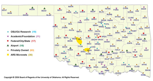
already met via the Oklahoma Mesonet, an automated network of 120
stations that collect real-time observations of soil and atmospheric
variables across the state (Fig. 1). However, the component needed to
monitor plant available water and dramatically improve drought
monitoring across Oklahoma is increased knowledge of the soil
properties at the Mesonet sites.

Fig. 1. The locations of the Oklahoma Mesonet
stations
Nature, scope, and objectives of the project:
The long term goal of the team of collaborators representing
Oklahoma State University, the Oklahoma Mesonet, the Oklahoma
Climatological Survey, and the University of Oklahoma is to develop and
implement a system for accurately monitoring soil moisture and plant
available water at each Mesonet station and to predict those values in
near real-time for all other locations across Oklahoma. The
objective of this proposal is to complete a critical first
stage of the research and improve drought monitoring in Oklahoma
through the development of a Mesonet-based system for tracking plant
available water. The central hypothesis of the proposed work is
that measuring key soil properties at each Mesonet site will allow the
proposal team to integrate the existing soil moisture data into an
accurate measure of plant available water. Preliminary data
presented in this proposal provide early support for this hypothesis.
The rationale for the proposed research is that providing resource
managers with real-time data on plant available water will enable them
to adopt management strategies (e.g. crop marketing contracts, cattle
stocking rates, hay purchases, fertilizer rate adjustments) to mitigate
drought impacts. The proposal team is well prepared to succeed
with this project due to the extensive expertise and strong achievement
records in soil moisture related research, leadership in managing the
Oklahoma Mesonet, and experience in the development of online products
through the popular websites www.mesonet.org and www.agweather.mesonet.org.
The following specific aims are proposed as part of the
project:
Specific aim #1: Determine the soil properties
controlling the plant availability of soil moisture at each Mesonet
site. Soil samples will be collected from every site and
key soil physical properties will be measured in the laboratory.
Specific aim #2: Develop a routine to calculate plant
available water by integrating the sensor output and the site-specific
soil properties. Existing pedotransfer functions will be used
together with the measured soil properties to translate the output from
the sensors (Campbell Scientific, Model 229, heat dissipation sensors)
into prototype plant available water maps.
Statement of results or benefits:
The proposed project is a truly unique research opportunity because
no other state in the nation and no other region
in the world has a soil moisture sensing infrastructure
comparable to that of the Oklahoma Mesonet. At the completion of
this project, it is expected that an innovative drought monitoring
system, providing resource managers with reliable, daily updated
information on the remaining reserves of plant available water, has
been developed and coupled with the unmatched resources of the Oklahoma
Mesonet. This system and the products developed will enable end
users to more effectively adapt their management strategies. For
example, by knowing early that plant available water is decreasing and
reaching critical minimum values, farmers could reduce mid-season N
fertilizer application rates on wheat, change forward contracting
strategies, or choose to graze out more wheat. Similarly,
ranchers, facing the potential for reduced pasture, could make early
arrangements to purchase hay or could sell cattle early, when prices
are more favorable. Further, government agencies, such as the
Oklahoma Water Resources Board, could gain a clearer picture of the
extent of drought effects in the state and could target relief efforts
more effectively.


